South Dakota
State Motto
South Dakota State Information
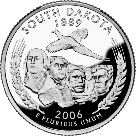
South Dakota, located in the northern region of the United States, is a state known for its vast expanses of natural beauty and rich cultural heritage. It is characterized by its iconic landscapes, including the dramatic peaks of the Black Hills, the sweeping plains of the Great Plains, and the meandering Missouri River. South Dakota is renowned for its historic landmarks such as Mount Rushmore, where the faces of four U.S. presidents are carved into the mountainside, and the Crazy Horse Memorial, dedicated to the Native American leader Crazy Horse. The state embraces its Native American heritage, with several reservations within its borders. Agriculture plays a significant role in South Dakota's economy, and it's known for its production of wheat, corn, and soybeans. Additionally, tourism is vital, drawing visitors to its national parks, outdoor recreational opportunities, and cultural events. South Dakota's friendly communities and strong sense of tradition make it a unique and inviting place to explore and experience American history and natural wonders.
What's in a name?
Dakota' is derived from the Dakota Sioux word 'Dakhóta,' meaning 'allies' or 'friends.'
State Nickname of South Dakota
South Dakota Geography

| Area: | 77,116 sq mi (199,730 km²), 17th |
| Highest Point: | Black Elk Peak; 7,244 ft (673 m), 15th |
| Lowest Point: | Big Stone Lake; 966 ft (90 m) |
| Bordering States: | Iowa, Minnesota, Montana, Nebraska, North Dakota, Wyoming |
| Area Codes: | Area Codes of South Dakota |
| Zip Codes: | Zip Codes of South Dakota |
South Dakota is characterized by its diverse geography. The state is known for its vast expanses of rolling prairies in the eastern region, where agriculture thrives, and its rugged terrain in the west, which includes the stunning Black Hills, a mountain range rich in natural beauty and mineral resources. Mount Rushmore, a renowned national monument, is carved into the granite of the Black Hills and symbolizes the state's historical significance. South Dakota also boasts the Missouri River, the longest river in North America, which bisects the state, offering fertile valleys and picturesque bluffs. The state's geography showcases a unique blend of natural wonders, from Badlands National Park's striking landscapes to the fertile farmlands in the east, making South Dakota a place of diverse beauty and outdoor adventure.
South Dakota Economy
The economy of South Dakota is characterized by a diverse mix of industries, with agriculture, healthcare, tourism, manufacturing, and retail trade playing prominent roles. Agriculture, particularly the production of corn, soybeans, wheat, and cattle, is a key driver of the state's economy, contributing significantly to its GDP. The healthcare sector has seen steady growth, with several major healthcare organizations headquartered in the state. South Dakota's picturesque landscapes and attractions, such as Mount Rushmore and the Black Hills, draw millions of tourists each year, boosting the tourism industry. Additionally, manufacturing, including food processing and machinery production, contributes to the state's economic stability. With a relatively low unemployment rate and a business-friendly environment, South Dakota maintains a healthy economic outlook, attracting businesses and fostering growth across various sectors.
Agriculture
Top 3 crops / livestock for South Dakota
- Soybeans
- Corn
- Cotton
Industry
Top 3 industries for South Dakota
- Agriculture
- Manufacturing
- Healthcare
South Dakota State Symbols
State Bird
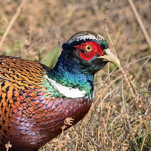 Ring-Necked Pheasant
State Flower
 Pasque Flower
State Tree
 Black Hills Spruce
State Mammal
 Coyote

Ted Grajeda
The50UnitedStates.com Owner
The 50 United States is a Ted Grajeda project created to provide everyone with a fun and interactive way to learn about the great 50 states of the USA. Learn more
State Quizzes & Flashcards
Test your knowledge of the 50 States of the USA with these fun and interactive quizzes & flashcards!
Fee USA Maps
Download and printout hundreds of state maps. Each state map comes in PDF format, with capitals and cities, both labeled and blank. Visit FreeVectorMaps.com for thousands of free world, country and USA maps. View all USA Maps


